skip to main |
skip to sidebar
6.9 magnitude quake strikes western Myanmar, shakes neighboring countries

April 2016 – YANGON – A magnitude 6.9 earthquake
struck Myanmar on Wednesday, causing tremors around the region,
including in neighboring Bangladesh where scores were reported injured
in stampedes and buildings were damaged. The quake, which took place at a
depth of 134 kilometers (83 miles), hit some 400 kilometers northwest
of Myanmar’s capital Naypyidaw, according to the US Geological Survey
(USGS), and was also felt in parts of India and China. There were no
immediate reports of casualties, although the region where the
earthquake hit has poor communications infrastructure like many of
Myanmar’s outlying provinces.
A lawmaker from the Sagaing region,
some 100 kilometers from the epicenter, told AFP she felt rough tremors
that lasted for several minutes. “There may be some destruction and
damage. But it’s difficult to know the (extent) of destruction at
nighttime,” Cho Cho Win said, adding that the town does not have many
high-rise buildings. Tin Nyo, 67, from another township in Sagaing, said
the earthquake was the strongest she had ever felt. “Although it
happened over a short period, it was really rough,” she said. Some in
Yangon – Myanmar’s former capital and biggest city – who also reported
feeling tremors fled their multi-story apartment buildings in fear.
The quake was also strongly felt across
Bangladesh, which shares a border with Myanmar. More than 80 people in
the country were injured, mostly in stampedes as panicked residents fled
their homes and offices, Channel 24 reported. In the port city of
Chittagong, some 200 kilometers from the Myanmar border, at least four
buildings stood on a slant following the quake. “Around 50 people were
injured in the Chittagong city, including 24 who were admitted to
hospital with minor injuries. They were mostly injured in stampedes,”
the city’s police constable Imran Hossain told AFP. Traffic ground to a
halt in parts of the capital Dhaka as tens of thousands of alarmed
residents rushed into the streets.
In neighboring India, tremors were felt
in the northeastern cities of Kolkata, Shillong, Guwahati and Patnam.
In Kolkata, one of India’s largest cities, startled residents ran from
their houses after the trembling. “I was inside, working and then
suddenly I felt the ground shaking,” local resident Chiranjeet Ghosh
told television news channels. “People started yelling ‘Something is
happening, let’s get out!’ and we immediately rushed out. I came out and
saw that everyone else around here had already evacuated their homes
and poured onto the streets.” Residents in Kolkata reported seeing
cracks appearing in buildings following the quake, and the city’s metro
was suspended for a few minutes.
Strong tremors were also felt in Tibet,
with some residents of Lhasa out on the streets, Chinese official news
agency Xinhua said. Earthquakes are relatively common in Myanmar, where
six strong quakes of 7.0 magnitude or more struck between 1930 and 1956
near the Sagaing Fault, which runs north to south through the centre of
the country, according to the USGS. Myanmar has not seen a major quake
since November 2012, when a powerful 6.8 magnitude earthquake struck the
centre of the country, killing 26 people and injuring hundreds. The
impoverished Southeast Asian nation, which is emerging from decades of
military rule, has a strained medical system, especially in its rural
states.
The breakneck pace of development in
Myanmar’s cities, combined with crumbling infrastructure and poor urban
planning, has also made the country’s most populous areas vulnerable to
earthquakes and other disasters, experts say. In 2015, severe flooding
swept across swaths of Myanmar, including the region where Wednesday’s
earthquake hit, leaving more than 100 people dead and affecting
thousands as rescuers struggled to reach isolated regions. –Bangkok Post

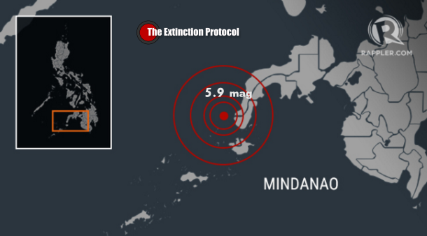
MANILA, Philippines – A 5.9 magnitude
earthquake hit off the coast of Mindanao early Thursday, April 14,
seismologists said, with no damage or casualties immediately reported
and no tsunami warning issued. The quake occurred at 2:21 am (1821 GMT
Wednesday) off the coast of Zamboanga del Norte, with its epicenter at a
depth of 15 kilometers, the Philippine Institute of Volcanology and
Seismology (Phivolcs) said.
The US Geological Survey, meanwhile,
located the quake’s epicenter about 28 kilometers (17 miles) northwest
of Siocon, Zamboanga del Norte, at a depth of about 12 kilometers. A
USGS map recorded moderate-strong shaking on coastal areas near the
quake’s epicenter, but said the risk of damage was not high. Local
authorities said there was no tsunami risk and that they had not
received reports of casualties or damage, but warned that some buildings
could be affected. –Rappler


0 comments:
Post a Comment