skip to main |
skip to sidebar
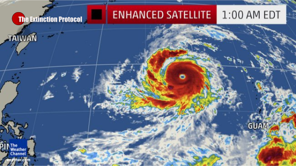
Dangerous: Super Typhoon Soudelor intensifies as the strongest storm of 2015, wind gusts 220 mph

August 2015 – TAIWAN – Soudelor
is intensifying rapidly over the western Pacific Ocean after raking
through Saipan, a U.S. commonwealth in the Northern Mariana Islands,
Sunday night and early Monday. Super Typhoon Soudelor became the fifth
super typhoon of this year Monday after undergoing a replacement of its
eyewall, a process which occurs in all intense tropical cyclones. A
super typhoon is defined by sustained wind speeds of at least 150 mph.
According to Monday’s 5 p.m. EDT bulletin from the Joint Typhoon Warning
Center, Soudelor had strengthened into the equivalent of a Category 5
hurricane with maximum sustained winds of 180 mph (one-minute average)
with gusts to 220 mph.
Soudelor has maintained its strength
and as of 11 p.m. EDT Monday, Soudelor continues to have maximum
sustained winds of 180 mph and some additional strengthening is
possible. Low wind shear and very warm sea surface temperatures have
allowed Soudelor to ramp up quickly; the cyclone was just a minimal
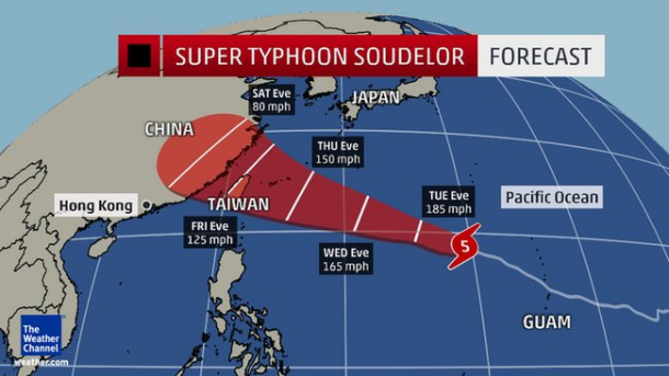
typhoon 36 hours earlier. Soudelor continues to track to the
west-northwest over the open waters of the Western Pacific. Soudelor has
become the strongest tropical cyclone seen anywhere on Earth so far in
2015, at least by JTWC satellite estimation. Cyclone Pam in March
reached peak estimated sustained winds of about 165 mph (145 knots) in
the South Pacific basin. On this path, Soudelor will move toward Japan’s
southwestern Ryukyu islands by Friday.
For now, the main island of Okinawa
(including Kadena Air Base) lies at the north end of the forecast swath,
but it remains far too soon to rule out a closer pass of the center of
Soudelor to Okinawa. Taiwan and China are also likely to be impacted by
Soudelor this weekend. Even though it may be weakening by then, Soudelor
could still be a very strong typhoon. Its center may pass directly over
Taipei, the Taiwanese capital. Intensifying from a Category 1 to
Category 2 equivalent storm, Soudelor’s eye passed directly over the
Island of Saipan, home to about 48,000 residents. A state of disaster
and significant emergency was declared by Acting Gov. Ralph DLG Torres.
High winds downed power poles, removed
roofs off buildings and flooded Saipan’s power plant. About 350 people
were in emergency shelters, as of Monday morning, the Pacific Daily News
reported. “From looking at the damage, I would guess weeks to months to
restore power. It took about three to six months to restore service on
Guam after Pongsona,” Dr. Phillip Dauterman told the Pacific Daily News
in an email. “This is not the total damage of Pongsona, but it is
close.” Saipan International Airport recorded a peak wind gust to 91 mph
just before 11 p.m. local time Sunday night, as the western eyewall
approached, before wind observations dropped off — not to mention the
instrumentation erroneously reported snow — for about an hour.
Soudelor passed north of Guam but wind
gusts over 30 mph and light rain were measured. High surf from Soudelor
will continue for the next few days. Soudelor, a name contributed by the
Federated States of Micronesia, was a legendary chief on the island of
Pohnpei, about 1,650 kilometers (1025 miles) east-southeast of Guam. –Weather


0 comments:
Post a Comment