


Showing posts with label volcano. Show all posts
Showing posts with label volcano. Show all posts
Tuesday, May 5, 2015

Wednesday, January 7, 2015
Time-bomb? Iceland volcanic eruption mystery – ground sinking below lava build-up by a foot a day
by The Extinction Protocol

January 2015 - SKAFTAFELL, Iceland -- Just
north of here, on the far side of the impenetrable Vatnajokull ice
sheet, lava is spewing from a crack in the earth on the flanks of
Bardarbunga, one of Iceland's largest volcanoes. By volcanologists'
standards, it is a peaceful eruption, the lava merely spreading across
the landscape as gases bubble out of it. For now, those gases --
especially sulfur dioxide, which can cause respiratory and other
problems -- are the main concern, prompting health advisories in the
capital, Reykjavik, 150 miles to the west, and elsewhere around the
country. But sometime soon, the top of Bardarbunga, which lies under as
much as half a mile of ice, may erupt explosively. That could send
plumes of gritty ash into the sky that could shut down air travel across
Europe because of the damage the ash can do to jet engines. And it
could unleash a torrent of glacial meltwater that could wipe out the
only road connecting southern Iceland to the capital. All of that could
happen. Then again, it may not.
Such
are the mysteries of volcanoes that more than four months after
Bardarbunga began erupting, scientists here are still debating what will
happen next. The truth is, no one really knows. Volcanic eruptions are
among the Earth’s most cataclysmic events, and understanding how and
when they happen can be crucial to saving lives and reducing damage to
infrastructure and other property. Scientists have several powerful
tools to help, but in the end, they are often reduced to analyzing
possibilities within possibilities, chains of potential events that
could unfold in multiple ways. “Volcanoes are really difficult to
predict because they are so nonlinear,” said Pall Einarsson, a
geophysicist at the University of Iceland. “They can suddenly decide to
do something very different.” For now, the eruption remains what
volcanologists call an effusive one -- the lava, consisting primarily of
molten basalt, is thin enough that the gases bubble out with little
explosive force.
And
the amounts of sulfur dioxide and other gases, while a concern locally,
are nowhere near the amounts produced by an eruption at a fissure
called Laki in the 1780s. In that event, the gases poisoned livestock
across Iceland, leading to a famine that killed about a quarter of the
country's population and had other effects in Europe and elsewhere. One
possibility is that the current eruption will eventually peter out as
the source of magma is depleted. “Maybe the most likely scenario is
something similar to what we've been seeing,” Sigmundsson said. But that
could take a while; although the volume of lava has declined, it has
done so only very gradually, he said, suggesting the eruption could
continue for many months. But there are many other possibilities.
Bardarbunga sits at the heart of a complex system of volcanoes and “has a
history of affecting its neighbors,” Einarsson said. Were the dike to
continue moving to the northeast, he said, it could set off an eruption
at the nearby Askja volcano, although that seems less likely.
Of
greater concern is what is happening at Bardarbunga's caldera, the
wide, deep valley at the top of the mountain that is filled with
hardened magma from past eruptive activity. Earthquake data and GPS
measurements show that this hardened magma, which acts like a plug, is
sinking, probably as the hot magma below it escapes through the fissure
to the north. The subsidence is astonishingly rapid, about a foot a day,
and the question is how much more of this the plug can take before it
breaks up. “As of now, the system seems to be relatively stable,”
Einarsson said. “But it's almost certain that this can't last very long,
and that's what people are worried about. Because this plug is bound to
disintegrate as it moves so much.” If the plug cracks apart, the hot
magma below would have a new, easier path to the surface -- straight up
-- where it would combine with ice to cause a steam-magma explosion.
Such an eruption could create a large plume of ash that could disrupt
air travel, as the eruption at another Icelandic volcano did in 2010.
Its effects on the surrounding region could be catastrophic as well,
with glacial meltwater collecting in the caldera until it overflows,
causing a vast flood.
That
has happened countless times in Iceland's geological history, and it is
what created the eerie skeidararsandur, the vast delta west of
Skaftafell that resembles the surface of the moon, as floodwaters
brought huge quantities of black volcanic sand down from the mountains.
The skeidararsandur could take the brunt of a flood again, although it
would depend on precisely where the eruption occurred. A short distance
this way or that, and the floodwaters might flow to the north, or even
to the west -- an especially troubling possibility given that several
hydroelectric dams responsible for much of Iceland's electricity could
be damaged or destroyed. “One can never be absolutely certain about
predicting,” Einarsson said. “So we have to line up all the possible
scenarios and stretch our imaginations to figure out what could possibly
happen.” –Alaskan Dispatch
Monday, February 17, 2014
Growing unrest: El Salvador’s San Miguel may be stirring for another eruption

February 17, 2014 – EL SALVADOR – Warning signs of a possible new eruption of the volcano in the near future are becoming increasingly alarming. Accompanied by an ongoing earthquake swarm, tremor (as an indicator of internal pressure) continues to climb. Pulsating gas emissions reaching 50-400 m height above the crater have been seen recently. Sulfur dioxide (SO2) emissions remain high. Depending on wind direction and speed, air quality in downwind areas near the volcano often reaches unhealthy values. Since 27 Jan, a total of 109 earthquakes were detected by MARN under the north flank of the Chaparrastique volcano, with magnitudes ranging between 0.6 and 1.9. –Volcano Discovery
http://theextinctionprotocol.wordpress.com/2014/02/17/growing-unrest-el-salvadors-san-miguel-may-be-stirring-for-another-eruption/


Phreatic explosions: locals warned of new eruptions from Peru’s Ubinas volcano

February 17, 2014 – PERU – The volcano could be in the process of entering a new eruptive phase. Two small (likely phreatic) explosions occurred last Friday at 13:46 and 14:45 h local time (18:46 and 19:45 GMT), ejecting plumes of ash and steam rising approx. 1.5-2 km. A strong sulfur smell was noticed in up to 5 km distance. Ubinas, Peru’s most active volcano, had been showing increased signs of unrest since the beginning of the month. Episodes of tremor occurred frequently during 1-9 Feb, accompanied by intense fumarolic activity. Tremor decreased after 9 Feb, but a swarm of long-period earthquakes occurred with up to 80 quakes detected per day. n important increase in SO2 emission (500 tons/day on 7 Feb) was measured, which suggests the presence of new magma. In addition, INGEMMET detected 25-30 mm inflation of the southern flank, but notes that it is likely a sign of its structural instability, enhanced by the current seismic activity (as opposed to being a sign of magma pushing from inside). Authorities have distributed dust masks to people in the areas of Cancosani, Titi and Cangalle. –Volcano Discovery
http://theextinctionprotocol.wordpress.com/2014/02/17/phreatic-explosions-locals-warned-of-new-eruptions-from-perus-ubinas-volcano/
Thursday, February 13, 2014
MASSIVE eruption Mt Kelud, Indonesia
http://beritajatim.com/peristiwa/198357/gunung_kelud_meletus_dua_kali,_pengungsi_berhamburan.html#.Uv0kkGJdWSp
Raining gravel 40 km away:
http://www.bom.gov.au/products/IDD41295.shtml
Video news report:
http://www.youtube.com/watch?v=Q3vBI0kVSBs
More pics here:
http://www.kaskus.co.id/thread/52fd1ae85bcb174d0800007e/erupsi-gunung-kelud-dalam-foto-13-2-14-2250wib?goto=newpost
Tuesday, February 4, 2014
28: Kavachi undersea volcano (Solomon Islands) erupts

February 1, 2014 – SOLOMON ISLANDS – A submarine eruption is likely occurring at the submerged volcano. A NASA satellite image from 29 Jan shows a plume of discolored sea water swirling and drifting from the location of the volcano. The discoloration is likely from suspended volcanic sediments (the fragmented lava) and gasses. Kavachi is an undersea volcano on the southern edge of the Solomon Islands in the western Pacific Ocean. It erupted dozens of times in the 20th century, often breaking the water surface, only to be eroded back below the water line within a few months. Whether the new eruption will break the surface and create another new island remains to be seen. Directly above the undersea peak, a bright patch is visible that suggests vigorously churning water—but there is no sign that the eruption has broken the surface. (NASA) –Volcano Discovery
Tuesday, December 24, 2013
Seismic unrest: new earthquake swarms reported at El Hierro Island

December 23, 2013 – CANARY ISLANDS - The new earthquake swarm under the island’s central-SE sector continues. So far, about 120 quakes of magnitudes above 1.8 including a handful of possibly felt ones (up to magnitudes 3.2) have occurred since yesterday morning. Preliminary GPS data suggest a new phase of uplift has started as well, which supports the idea that a new magma intrusion is occurring at the base of the upper crust beneath the volcanic island. A new earthquake swarm started under the island on December 22nd. The earthquakes are located at about 15 km depth under the southeastern central part of the island. IGN recorded more than 40 quakes with magnitudes up to 3.2 so far. Whether the earthquakes are related to new magmatic intrusions at depth is a unknown but a possible scenario. –Volcano Discovery
Thursday, November 21, 2013
Seven Volcanoes In Six Different Countries All Start Erupting Within Hours Of Each Other
Chris Carrington
Activist Post
A new island has appeared in the Pacific. A submarine eruption just off Nishino-Shima Island Japan has erupted for the first time in 40 years. The Japanese Navy noticed the explosions as boiling lava met sea water giving rise to plumes of steam and ash.
Almost 7,000 miles away in Mexico, the Colima volcano blew its top after a period of relative calm. A steam and ash cloud rose two miles into the sky and the grumbling of the mountain could be heard in towns a few miles away.
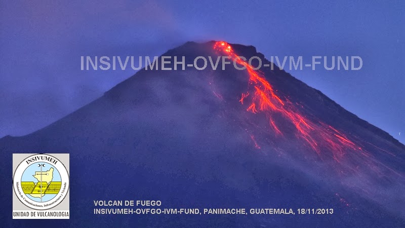
In Guatemala the ‘Fire Mountain’ belched out lava and sent up a moderate ash cloud causing an ash fall over nearby towns. The explosions and shock waves occurring in the volcano can be felt by residents over 6 miles away. Doors and windows are reported to be rattling, but there has been no damage so far.
In Vanuatu the Yasur volcano is giving some cause for concern. Although the explosions are quite weak the continuous ash that is coming from the mountain is starting to build up on farming land.
Over to Italy, Mount Etna is putting on quite a display. The current eruption started a few days ago and has been getting stronger as time moves on. A massive eruption lit up the sky and disturbed residents yesterday. The ash cloud was high enough to see flights canceled. The lava flow was the biggest in years, and the town of Zafferana which lay in its path saw some damage. Lava diverters were put into place, and most of the town escaped unscathed.
Activist Post
A new island has appeared in the Pacific. A submarine eruption just off Nishino-Shima Island Japan has erupted for the first time in 40 years. The Japanese Navy noticed the explosions as boiling lava met sea water giving rise to plumes of steam and ash.
Almost 7,000 miles away in Mexico, the Colima volcano blew its top after a period of relative calm. A steam and ash cloud rose two miles into the sky and the grumbling of the mountain could be heard in towns a few miles away.
In Guatemala the ‘Fire Mountain’ belched out lava and sent up a moderate ash cloud causing an ash fall over nearby towns. The explosions and shock waves occurring in the volcano can be felt by residents over 6 miles away. Doors and windows are reported to be rattling, but there has been no damage so far.
In Vanuatu the Yasur volcano is giving some cause for concern. Although the explosions are quite weak the continuous ash that is coming from the mountain is starting to build up on farming land.
Over to Italy, Mount Etna is putting on quite a display. The current eruption started a few days ago and has been getting stronger as time moves on. A massive eruption lit up the sky and disturbed residents yesterday. The ash cloud was high enough to see flights canceled. The lava flow was the biggest in years, and the town of Zafferana which lay in its path saw some damage. Lava diverters were put into place, and most of the town escaped unscathed.
Subscribe to:
Posts (Atom)

